You consider climbing the Cotopaxi and you want to have more detailed insights about the volcano? With this article you get to know all the facts & information about Cotopaxi. In the first chapter we will describe you the technical data of Cotopaxi. Here you get to know the heights of the Cotopaxi, the difficulty of the ascent, the mountain range, the tour data, the estimated climbing time, the best season to climb the Cotopaxi and the temperatures. In the second chapter you get to know some interesting facts about Cotopaxi. The origin of the name, the mythology, the history, the first ascents and the panorama will be described there.
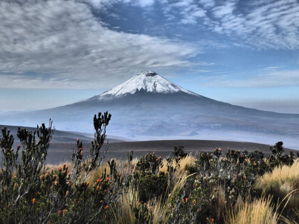
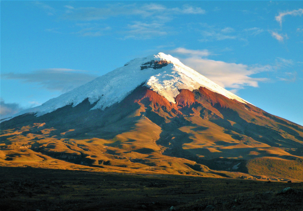
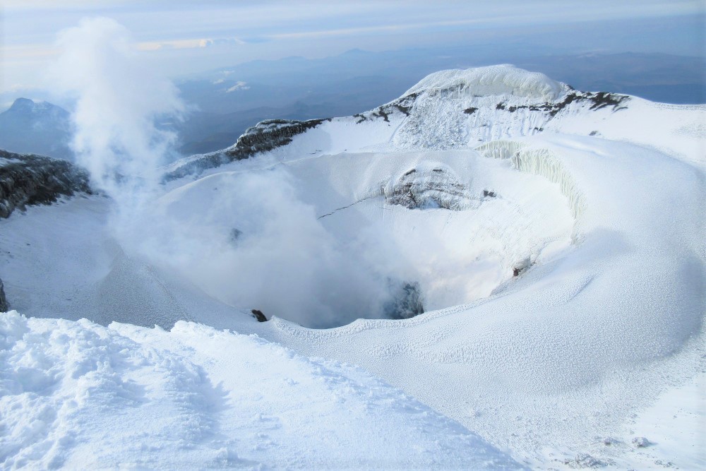
The Ecuadorian volcano Cotopaxi is the third-highest active volcano in the world. Cotopaxi is in the Cotopaxi national park about 50 kilometers south of Quito. Due to its proximity to the Oriente, it is susceptible to the weather, but it is located in a fairly dry and stable zone, which means that it can be climbed almost all year round. This makes him the most climbed five-thousand-meter volcano in South America. The popularity comes from its easy accessibility and the low technical degree of difficulty of the ascent. Further he belongs to the “Avenue of Volcanoes” in the eastern Andes. That avenue consists of the most significant volcanos in Ecuador like the Cayambe in the north of Quito, the very active Tungurahua in Baños, the Illinizas in the south of Quito and the Chimborazo, which is the highest volcano in Ecuador. Due to its regular conical shape and the ice cap on the summit, Cotopaxi corresponds to the ideal image of a stratovolcano. The crater at the summit has a diameter of 800 meters × 550 meters and is about 350 meters deep.
Technical Data
In this paragraph we give you all essential technical data of Cotopaxi to be perfectly prepared for your next ascent.
Height of Cotopaxi
The Cotopaxi has a north summit and a south summit, where the north summit with 19347 ft / 5897 m is 77 m higher than the south summit. With its elevation, Cotopaxi is one of the highest active volcanos in the world. Only the Ojos del Salado (6,893 m / 22,615ft) and the Tupungato (6,550 m / 21,490 ft) on the boarder of Chile and Argentina are higher in this ranking.
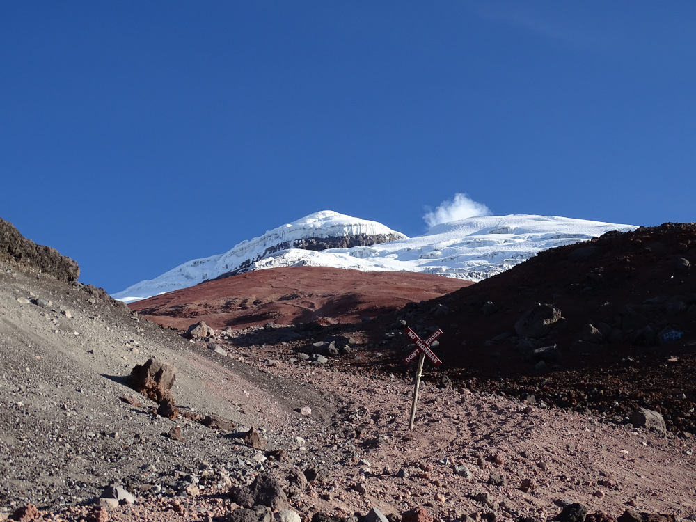
At about half the height of the cone, at 4800 m / 15748,03 ft, the Refugio Jose F. Ribas was built in 1971 by the Club de Andinismo San Gabriel. The parking spot of the Cotopaxi national park, which is normally the starting point of the ascent, lies on an elevation of 4600 m / 15091,86 ft. The glacier of Cotopaxi starts at 5100 m / 16732,28 ft. For comparison, the closest city is Latacunga at 2850 m / 9350,39 ft and Quito, the capital at 2816 m / 9238,84 ft.
Difficulty of the Ascent
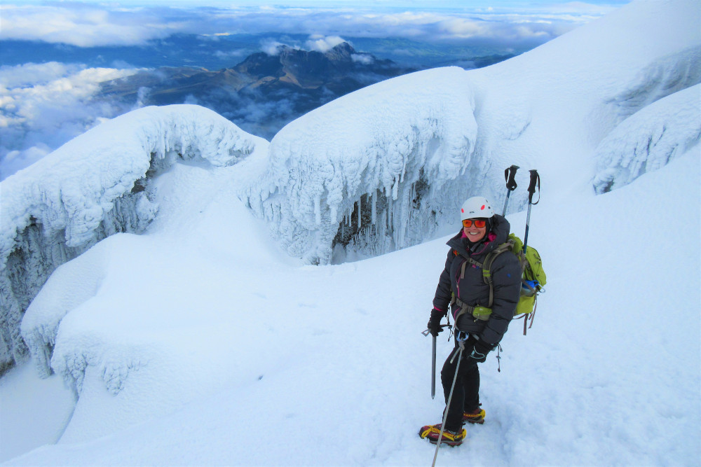
The normal route basically offers no great technical difficulties, but nevertheless it does require crampons, ice axe and rope. Although it is often quite steep, each steep section is always followed by a flatter zone. The Cotopaxi can theoretically be climbed in two days with one overnight stay in the refuge. Due to the altitude of Cotopaxi, an acclimatization is recommended before climbing to reduce the symptoms of altitude sickness. In addition, the mountaineer should be in an excellent physical condition, because the ascent is very physically demanding.
Mountain Range
The Cotopaxi is located near the Panamericana, about 55 km south of Quito. Apparently, it is an inner-Andean mountain, but geologically it is attributed to the Cordillera Central. The Cordillera Oriental of the Andes which runs north – south the length of the country, has the youngest and most active volcanos, where the Cotopaxi is the highest of them. This mountain range is flanked in the west by the Interandean region and in the east by the Amazon. The relatively large distance to the eastern range of the Andes gives the Cotopaxi a high number of clear days.
Further, the Cotopaxi is about 75 km air-line distance away from the equator and near the Oriente, therefore already in the late morning the snow becomes very soft and from about 10.00 o’clock mostly clouds from the east come up.
Tour Data
There are two possible routes to the summit of the Cotopaxi, the northern route and the southern route. Thus, we describe the northern route, as this route is basically used for the ascent to the summit. From the refugee the northern route is about 1.200 m / 3,937 ft in vertical elevation gain and 3 km / 1.86 miles to the summit.
Cotopaxi Tour Details
The starting point of the ascent to the summit is at the Cotopaxi national park parking area. From there a steep sandy slope leads to the refuge at 4800 m / 15748,03 ft.
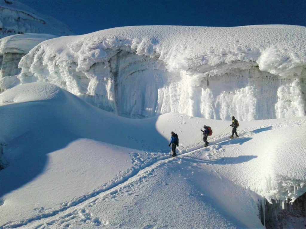
From the refuge, tracks lead in the direction of the steepest slope to the edge of the glacier. The sandy slope below the glacier is covered with more or less snow depending on the weather conditions of the last months, so that crampons are sometimes necessary even before the glacier. The glacier is reached at an altitude of about 5100 m / 16732,28 ft. You first climb a pulpit at 5140 m / 16863,52 ft directly above the glacier entrance. The first few meters can be steep. From here you follow a slightly pronounced rib in the direction of 170 degrees. At an approximate height of 5330 m / 17486,88 ft you reach a corner point. Here you are now exactly in the rock face of Yanasacha. From here you must go to the right at 254 degrees. This way you reach a wide, flatter rib at 5480 m / 17979 ft.
Depending on the conditions, the ascent to this point is also made in direct line from the glacier entrance. You follow the rib towards 174 degrees. The route leads about 200 m west of Yanasacha. Then you cross a hollow at 5580 m / 18307,09 ft until you reach the foot of the final slope. This slope is climbed in a gentle S-line. At the end of the S-line you reach a saddle in the outer crater rim. From here the main summit is reached in a few minutes.
The Cotopaxi is also part of our premium packages. You can check out all the details of the tours here.

Estimated Climbing Time
To estimate the Cotopaxi climbing time for an amateur climber we calculate with 195 m / 640 ft for the ascent and for the descent with 500 m / 1,640 ft vertical elevation gain per hour. After the calculation, this results in a time of 8 hours 33 minutes. For the horizontal distance we calculate with 6 km / 3.7 miles for ascent and descent. If you walk with 4 km / 2.5 miles per hour this would take us to 1 hour and 30 minutes. Finally, you must halve the smaller time. This results in a total time of 9 hours and 18 minutes (6 h 9min + 45min). This calculation is based on the book “Handbook for trekking- and altitude medicine, 2009” of Franz Berghold and Wolfgang Schaffert.
However, the climbing time depends also on other factors such as weather and trail conditions or the physical condition of the mountaineer. For more detailed information about climbing time estimations check out this blog article.
Best Season
Cotopaxi is a year-round destination and it’s possible to climb him in every season of the year. Between November and February there are relatively stable conditions where the number of sunny and clear days is higher compared to the other months. From March to May the climate is rather cloudy, windy and the amount of precipitation is high. In the summer months of June and August the weather is windy and cold. In September and October, the weather is quite stable with cloudy and clear conditions.
For a detailed weather forecast of the Cotopaxi visit mountain-forecast.com.
Temperature
It’s temperature depending on the altitude. It varies from the extreme of -10 degrees Celsius in the glacier region, to 20 degrees Celsius in the sunniest days on the lower moor. The temperatures at the height of the refuge are on average at 19:00 o’clock at +5° Celsius and around 24:00 o’clock at 0° Celsius. Due to the lively wind on the summit, the subjective perception of the temperature is on average up to -10 degrees lower.
Interesting Facts about Cotopaxi
The origin of the name Cotopaxi
According to Marco Cruz, the name “Cotopaxi” comes from the Cayapa language. “Coto” means “neck”, “pagta” means “sun” and “shi” can be translated as “sweet”. The result is a somewhat improbable translation: “Sweet neck of the sun”. More likely is the translation “fiery abyss” from the pre-Columbian language of the Panzaleos. Condamine, on the other hand, translates the name as “The mountain that shines”.
There is also another translation from the old Indian language Quichua. In this translation “Coto” means Adam’s apple, “pa” means respect and “xi” means emphasis.
Mythology of Cotopaxi
Like most mountains in Ecuador, the Cotopaxi occupies an important position in the mythology of the Indians. Here is a narrative taken from “Los cuentos de cuando los huacas vivian”: “In past times the mountains lived like us humans. Cotopaxi was considered a woman, Chimborazo as a man. The Chimborazo asked for the hand of the Cotopaxi, but she was in love with the Imbabura. But this did not stop the Chimborazo from courting her. The flirtatious Cotopaxi did not have only one lover. She also flirted with the Tungurahua and often met with Chimborazo’s neighbour, the Carihuairazo. When the Chimborazo heard of all these happenings, he stood up to the Carihuairazo. The Chimborazo took a stick and beat the Carihuairazo with his long arms. For this reason, the Carihuairazo remained full of stones and incisions, emaciated and desolate.”
However, a second version of the legend describes Cotopaxi as an elegant man who fought with the imposing Chimborazo for the hand of the beautiful Tungurahua. After years of courtship, Mama Tungurahua
chose the Chimborazo. This rejection made the Cotopaxi so angry, that even today the people who lived around him have to handle his outbursts.
History of Cotopaxi
The history of Cotopaxi is basically a series of destructions. Like other volcanoes of Ecuador, Cotopaxi does not endanger the environment by the direct effects of its eruptions such as lava or ash, but rather by the secondary effects of the eruptions. The heat of an eruption melts parts of the glacier. The resulting water masses expand into so-called lahars. A lahar is a mixture of mud, sand, stones and boulders and razes everything in its way to the ground.
Before 1900
The first historical eruption dates from 1534, followed by two devastating eruptions for Latacunga in 1742. One year later another eruption occurred. In 1744, following another eruption in Latacunga, the whole “Barrio caliente”, left of the “Cutuchi River”, was razed to the ground. In a distance of 10km of the volcano 10cm volcanic ash were measured. The eruption of 1766 also resulted in the emission of a large amount of volcanic ash. In 1768 an eruption was followed by explosions that could be heard all the way to Guayaquil. Three smaller eruptions followed in 1854, after which the volcano was quiet for 23 years. On 28.6.1877, after some smaller eruptions, it came to a larger eruption. During this eruption enormous lahars were formed. After one hour these streams had already razed the plains of Latacunga and the Valle de Chilo and flooded them with sand. In Latacunga, mud remained at the height of one meter.
After 1900
After minor eruptions in 1903 and 1904, the volcano has been quite silent since these events. The most recent eruption of the Cotopaxi occurred in 2015. During this eruption, explosions occurred inside the volcano and the ash floated more than five kilometres high in the air, which stretched as far as the capital Quito, 60 kilometers away. Current signs that Cotopaxi is active are limited to a few fumaroles on the inner flanks of the crater. Volcanologists have calculated that on average an eruption can be expected every 117 years.
First ascents of Cotopaxi
Unlike most of Ecuador’s high mountains, Cotopaxi was not first climbed by E. Whymper. On 28.11.1872, eight years before Whymper visited the Andes, the German alpinist Wilhelm Reis and his Colombian servant Angel M. Escobar climbed over the southwest side to the crater rim. However, the highest point in the crater rim, the northern summit, was reached on 9.9.1877 by the German geologist Theodor Wolf and Alejandro Sandoval via the north-western flank. The eruption of June 1877 had melted large parts of the glacier, so that Wolf could ascend largely over rock and sand.
Panorama of Cotopaxi
The panorama sight from the top of Cotopaxi is considered as one of the best views all around Ecuador, because in clear weather you can possibly see around 20 Ecuadorian volcanos. The following table shows all the information & data about the volcanos which you can possibly see:
| Cardinal Point | Volcano | Height [m/ft] | Air-line Distance [km/miles] |
|---|---|---|---|
| West | Illiniza South and North | 5248 / 17218 | 25 / 15,5 |
| NW | Corazon | 4788 / 15709 | 25 / 15,5 |
| NNW | Rumiñahui | 4712 / 15459 | 12 / 7,5 |
| NNW | Atacazo | 4410 / 14469 | 40 / 25 |
| NNW | Rucu Pichincha | 4737 / 15541 | 65 / 40 |
| North | Pasachoa | 4200 / 13780 | 25 / 16 |
| North | Cotacachi | 4966 / 16293 | 120 / 75 |
| NNE | Imbabura | 4550 / 14928 | 100 / 62 |
| NE | Sincholagua | 4893 / 16053 | 20 / 12 |
| NE | Cayambe | 5790 / 18996 | 100 / 62 |
| NE | Sara Urcu | 4725 / 15502 | 100 / 62 |
| ENE | Antizana | 5704 / 18714 | 40 / 25 |
| East | Sumaco | 3900 / 12795 | 150 / 93 |
| SE | Quilindaña | 4878 / 16004 | 15 / 9 |
| SE | Cerro Hermoso | 4571 / 14997 | 60 / 37 |
| South | Sangay | 5230 / 17159 | 150 / 93 |
| South | Altar | 5404 / 17730 | 110 / 68 |
| South | Tungurahua | 5023 / 16480 | 85 / 53 |
| WSW | Chimborazo | 6310 / 20702 | 100 / 62 |
| WSW | Carihuayrazo | 5020 / 16470 | 100 / 62 |
[…] Facts & Information Cotopaxi Volcano – ASA-Travel […]